In 1972 mum, dad, Mike and Pat took part in walking the Tasmanian Overland Trail. This expedition has always resonated with me as something I have wanted to do. Like most of us, something that we think about but realised that I have to actually get fit to do it.
Dad told me that back in the day when they were preparing for the walk they started out by walking around the nearby racecourse. Gradually increasing the times that they walked around it. They added an empty backpack then slowly started adding and increasing the weight in the backpack. Of course, the backpacks back then were pretty basic. The frame was on the outside of the packs. The packs today are amazing in comparison.
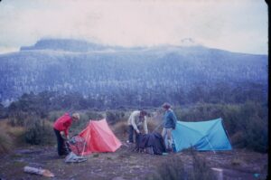
In fact, the doctor recommended that it was not a good idea for mum to undertake the walk. Mum had a heart condition from the age of four, but she was determined not to let that stop her. She did what she needed to do, and I am so proud of what she achieved by completing the walk.
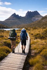
What is the Overland Track? The walk is 65 kilometres from Cradle Mountain to Lake St Clair. It’s in the Cradle Mountain-Lake St Clair National Park, part of the Tasmanian Wilderness World Heritage Area.
The walk on average takes 6 days (5 nights), some walkers stretch it out to 7 or more days by completing all the side trips and walking to the end of Lake St Clair.
The walk is classed as a grade 4, it can be quite rough and steep and has varying surfaces to contend with from boardwalks to rocks, mud and exposed tree roots.
It’s also noteworthy to mention that the weather can change quite rapidly with rain, cold wind and snow being possible in the summer. In fact, it snowed when mum and dad did the walk. I remember dad telling me that he had never felt so cold in his life as when he did the walk. Apparently, his zipper even froze on his jacket, and his hands were so cold from filming that mum had to help him get his jacket off.
There are huts along the trail that can be used along with camping spots to set up your tent. The huts have basic facilities, bunks, water and toilets. You can’t book a hut; it’s on a first come first serve basis so you need to be self-contained for camping out.
The walking season runs from October 1st to May 31 each year and must be booked online ahead of time. You can book online from July each year for the following season.
Most walkers arrive at Cradle Mountain Visitor Centre then take the Shuttle to the beginning of the trail at Ronny Creek.
At the end of the walk there is a ferry that you can use to cross Lake St Clair to the visitor centre. It is recommended that the ferry is prebooked. Otherwise, you can walk the additional 17.5 kilometres along the shoreline to Cynthia Bay.
Why walk the trail? What are the highlights?
Cross Alpine moorlands and plateaus above 1000 metres. Walk through rainforest, lakes, along mountain ridges. See flora and fauna that is not found anywhere else on earth. A side trip to Mt Ossa, Tasmania’s tallest Mountain is also an option.
What is the walk like? What do you need to bring? A typical day will include 6 to 7 hours of walking. You need good rain gear, warm layers, good boots and lots of food. The best time to walk is between December and February.
History of the trail. In the early 1900’s there was a rough route through the mountain which gradually became a recognisable walk by the 1930’s.
In 1910 Austrian Gustav Weindorfer a farmer and conservationist climbed Cradle Mountain and declared “This must be a national park for the people forever” He and his wife Kate settled in the area and worked to promote the area. His belief was that the area would only be valued and protected if it could be experienced.
The huts were constructed in the 20’s and 30’s and were then rebuilt and upgraded in the 1980’s. The walk slowly gained popularity from the 50s to the 70s and the film that my parents made definitely highlighted the difficulty of the walk.
So here is my challenge to myself. No more talking about it. I am going to start walking, I am going to get fit enough so that next year, I am thinking about in February, I am going to finally tick something off my bucket list and walk the overland trail. Wish me luck, I have a big journey ahead of me.
Walking Itinerary below:
Cradle Mountain to Lake St Clair (≈65 km)
________________________________________
Day 1 – Cradle Mountain → Waterfall Valley
Distance: ~10.5 km
Time: 4–6 hrs
Start at Ronny Creek, climbing steadily onto the alpine plateau.
• Optional Cradle Mountain summit side trip if weather is good (adds 2–3 hrs).
• Dramatic views across Dove Lake and the Central Highlands.
Overnight: Waterfall Valley Hut or tent platforms
Vibe: Big scenery, excitement high, weather can be wild.
________________________________________
Day 2 – Waterfall Valley → Lake Windermere
Distance: ~7.8 km
Time: 3–4 hrs
A gentler day across open moorland.
• Wide views, changing light, lots of wombats.
• Often finished by early afternoon — great for relaxing by the lake.
Overnight: Lake Windermere Hut / platforms
Vibe: Calm, scenic, deceptively exposed in bad weather.
________________________________________
Day 3 – Lake Windermere → Pelion
Distance: ~16.8 km
Time: 6–8 hrs
The longest walking day.
• Forest walking through myrtle and pencil pine.
• Cross Forth River and pass historic Pelion Plains.
Overnight: Pelion Hut / platforms
Vibe: A proper bushwalking day — long but rewarding.
________________________________________
Day 4 – Pelion → Kia Ora
Distance: ~9.6 km
Time: 4–6 hrs
A highlight day.
• Optional Mt Ossa side trip (Tasmania’s highest peak) if weather allows (adds 3–4 hrs).
• Visit Kia Ora Falls and Du Cane Falls — some of the best waterfalls on the track.
Overnight: Kia Ora Hut / platforms
Vibe: Iconic Overland scenery.
________________________________________
Day 5 – Kia Ora → Windy Ridge (Narcissus area)
Distance: ~9.7 km
Time: 4–5 hrs
Walk through rainforest and button grass plains.
• Feel the landscape subtly shift as you move south.
• Quieter, more reflective stretch of the walk.
Overnight: Windy Ridge Hut / platforms
Vibe: Peaceful, remote, classic Tasmanian forest.
________________________________________
Day 6 – Windy Ridge → Lake St Clair
Distance: ~10 km to Narcissus + ferry
Time: 3–4 hrs walk
• Easy walk to Narcissus Hut.
• Catch the Lake St Clair ferry to Cynthia Bay (book ahead).
Optional: Walk the 17.5 km lake edge track instead of ferry if you want a huge final day.
Finish: Lake St Clair Visitor Centre
Vibe: Quiet satisfaction… and very sore legs.